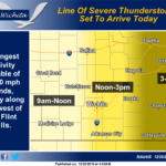
 A line of strong to severe thunderstorms will race east across the area today. The thunderstorms will affect locations generally west of I-135 before noon, locations between I-135 and the Flint Hills between noon and 3 pm, and far Eastern Kansas between 3 and 6 pm. The primary threat would be damaging 60 to 70 mph winds, especially along and west of the Flint Hills.
Christmas Day: Rain and thunderstorms before 3pm, then a slight chance of showers and thunderstorms between 3pm and 5pm. Some of the storms could be severe. Areas of dense fog before 9am. High near 66. Windy, with a southeast wind 16 to 21 mph becoming south 27 to 32 mph in the afternoon. Winds could gust as high as 40 mph. Chance of precipitation is 80%.
Sunday Night: Mostly clear, with a low around 29. Breezy, with a south southwest wind 20 to 25 mph becoming west 10 to 15 mph after midnight. Winds could gust as high as 32 mph.
Monday: Sunny, with a high near 47. West northwest wind 5 to 11 mph.
Monday Night: Clear, with a low around 24. West southwest wind around 6 mph.
Tuesday: Sunny, with a high near 50.
Tuesday Night: Mostly clear, with a low around 28.
Wednesday: Sunny, with a high near 52.
Wednesday Night: Mostly clear, with a low around 27.
Thursday: Sunny, with a high near 47.
Thursday Night: Mostly clear, with a low around 24.
Friday: Sunny, with a high near 47.
Friday Night: Partly cloudy, with a low around 29.
Saturday: Mostly sunny, with a high near 47.