 Rainfall varied; some locations received more than an inch
Several thunderstorms that had produced tornadoes earlier Friday evening in the western part of the state rumbled through our area overnight and more are expected for today.
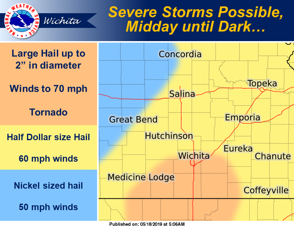
According to the National Weather Service office in Wichita (NWSW), thunderstorms are likely across the entire area today and early tonight. Severe storms, capable of quarter size hail and 60 mph winds will be possible from midday through early this evening, generally east of a Lincoln to Great Bend line.
There is potential for an elevated severe risk late this afternoon or early evening, with storms capable of a brief tornado and hail to around two inches in diameter over southern portions of south central Kansas.
Storms today and early tonight will also be capable of locally heavy rainfall and minor lowland flooding.
Overnight rainfall in Salina was approximately 0.3 of an inch. While most locations in our area saw less than half an inch of rain, a few locations picked up more. Here are some of the reported rainfall totals for the area:
CLAY COUNTY
12.4 miles north-northeast of Clay Center, 0.86 of an inch
0.4 of a mile north-northwest of Clay Center, 1.08 inches
0.3 of a mile east-southeast of Clay Center, 1.02 inches
6.7 miles west-northwest of Clay Center, 0.48 of an inch
3.2 miles southwest of Morganville, 0.46 of an inch
CLOUD COUNTY
9.3 miles south-southwest of Concordia, 1.36 inches
DICKINSON COUNTY
0.3 of a mile northwest of Enterprise, 0.18 of an inch
6 miles north-northeast of Chapman, 0.76 of an inch
0.3 of a mile south of Hope, 0.26 of an inch
2.1 miles north-northwest of Carlton, 0.24 of an inch
0.7 of a mile west of Abilene, 0.17 of an inch
ELLSWORTH COUNTY
5.5 miles west of Brookville, 0.48 of an inch
4.1 miles north of Geneseo, 0.29 of an inch
0.8 of a mile southwest of Kanopolis, 0.22 of an inch
0.3 of a mile east of Ellsworth, 0.35 of an inch
6.2 miles north-northwest of Holyrood, 0.54 of an inch
JEWELL COUNTY
0.3 of a mile west of Formoso, 0.14 of an inch
LINCOLN COUNTY
4.6 miles south of Beverly, 0.35 of an inch
McPHERSON COUNTY
0.7 of a mile north-northwest of Lindsborg, 0.4 of an inch
3.2 miles north of Canton, 0.13 of an inch
2.2 miles west of Moundridge, 0.03 of an inch
2.3 miles north-northeast of Marquette, 0.26 of an inch
MITCHELL COUNTY
4.6 south-southwest of Scottsville, 0.9 of an inch
9.9 south-southwest of Beloit, 0.56 of an inch
2.1 miles north-northwest of Hunter, 0.35 of an inch
6.9 miles northeast of Beloit, 0.58 of an inch
REPUBLIC COUNTY
1.2 miles southeast of Munden, 0.29 of an inch
6.1 miles north of Courtland, 0.22 of an inch
1 mile north-northwest of Republic, 0.19 of an inch
SALINE COUNTY
0.7 of a mile south-southwest of Salina, 0.26 of an inch
1.1 miles northeast of Gypsum, 0.15 of an inch
5.9 miles north-northwest of Brookville, 0.59 of an inch
4.3 miles southeast of Assaria, 0.27 of an inch
1.8 southeast of Culver, 0.68 of an inch