After last nights deluge, the National Weather Service (NWS) has issued several flood warnings for our area.
Good soaking overnight; more rain expected
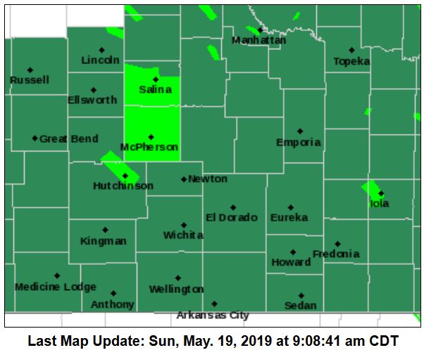
In addition to the following flood warnings, NWS has issued a flash flood watch for Ellsworth, Lincoln, Marion, McPherson, and Saline counties, from 1 p.m. Monday to 4 p.m. Tuesday. A number of other counties outside our area
Widespread heavy rainfall is expected from Monday afternoon through Tuesday morning, before ending by early Tuesday afternoon. Rainfall amounts in excess of three inches are likely with locally higher amounts possible.
The expected heavy rainfall will result in significant rises on area rivers and creeks with some likely to exceed flood stage. Locally intense rainfall may also lead to flash flooding of rural and urban areas.
Additionally, NWS has issued a flash flood watch for Clay, Cloud, Dickinson, Ottawa, and Republic counties from 1 p.m. Monday to 7 p.m. Tuesday.
An additional round of heavy rainfall is expected Monday afternoon through Tuesday. Additional rainfall amounts of 2 to 5 inches are expected, with locally higher amounts likely. Soils remain saturated from the numerous rain events over the past few weeks. As a result, any additional rainfall could lead to flash flooding and river rises.
Following are the flood warnings from NWS.
SALINE AND McPHERSON COUNTIES
A flood warning for Saline and McPherson counties is in effect until 3:45 p.m. Sunday. At 8:41 a.m., local law enforcement reported flooding throughout the counties. Up to three inches of rain have fallen.
CHAPMAN CREEK
A flood warning is in effect for Chapman Creek until Tuesday morning. 3:45 a.m. Sunday the creek was already above flood stage (19 feet) at 19.5 feet. The creek is expected to continue rising to near 21.1 feet by Sunday afternoon. The creek is expected to fall below flood stage Monday before midnight. At 19 feet, lowland flooding occurs from near the town of Industry upstream from Chapman to the Smoky Hill River downstream from Chapman.
MULBERRY CREEK
A flood warning for Mulberry Creek near Salina is in effect until Monday morning. The creek is expected to rise above flood stage (24 feet) by late this morning and continue to rise to near 25.6 feet by Sunday afternoon. The creek is expected to fall below flood stage by Sunday evening. At 26 feet, widespread agricultural flooding can be expected.
REPUBLICAN RIVER
A flood warning for the Republican River at Clay Center is in effect until late Tuesday night. The river was expected to rise above flood stage (15 feet) by early this morning and continue to rise to near 17.5 feet by Monday morning. The river is expected to fall below flood stage by early afternoon Tuesday. At 17.0 feet, flooding occurs between 16th, 17th, and 18th roads and between Limestone and Osage roads.
SALINE RIVER
A flood warning for the Saline River near Lincoln is in effect until Monday afternoon. The river is expected to rise above flood stage (30 feet) by late Sunday morning and continue to rise to near 32.3 feet by Sunday evening. The river is expected to fall below flood stage by Monday morning. At 32 feet, the lowlands around the river gauge site begin to flood. Much of this lowland is cultivated land.
SALT CREEK
A flood warning for Salt Creek at Barnard is in effect from Sunday afternoon until further notice. The creek is expected to rise above flood stage (21 feet) up to 23.1 feet by early Monday morning. At 23.0 feet, the North 250th Road by the Salt Creek Bridge will have water over the road in the section about 1/2 block north of the bridge where the road bends.
SMOKY HILL RIVER
A flood warning for the Smoky Hill River near New Cambria is in effect from Monday morning to Tuesday morning. The river is expected to rise above flood stage (27 feet) by Monday morning and continue to rise to near 27.6 feet by early Monday afternoon. The river is expected to fall below flood stage by Monday evening. At 27 feet, expect flooding of low-lying areas and bottom land along both sides of the river.
SOLOMON RIVER
A flood warning for the Solomon River near Glasco is in effect until late Sunday night. The river is expected to rise above flood stage (22 feet) and continue to 24.4 feet, before falling below flood stage later Sunday morning.