 The storms that rolled through overnight brought varying amounts of rain to the area.
Overnight thunderstorms batter Salina
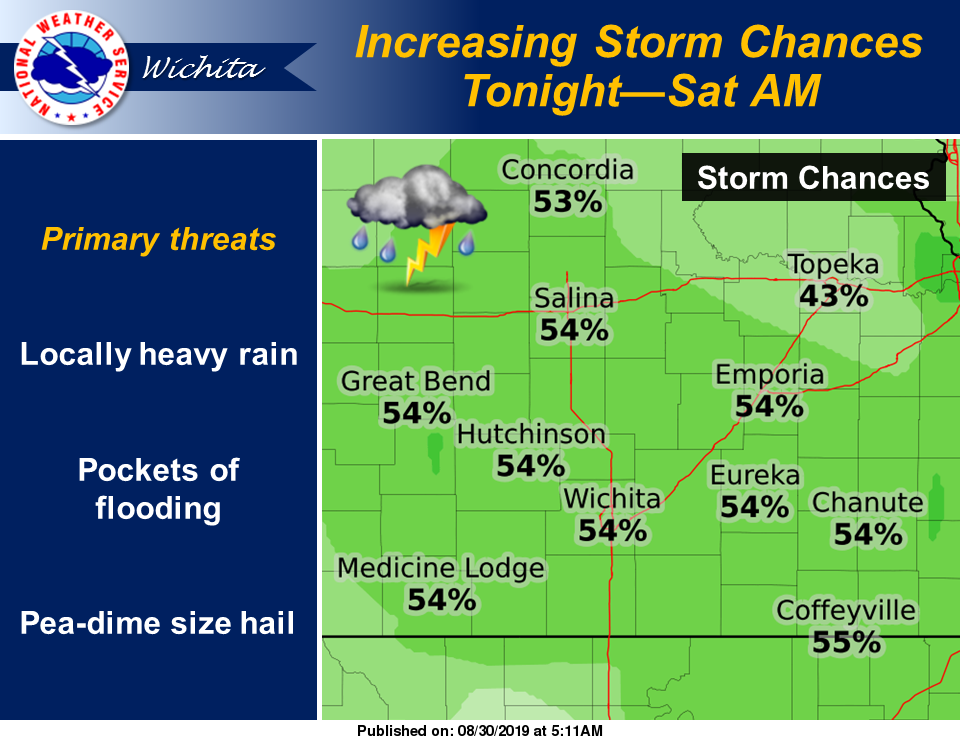
According to the National Weather Service, thunderstorms may increase across the region once again tonight. Strong to marginally severe storms are possible, along with locally heavy rainfall, which may once again support pockets of flooding.
Thunderstorm chances will linger across the region Saturday and Saturday night. A few strong storms cannot be ruled out, along with locally heavy rain.
Following are rainfall totals as of 7 a.m. Sunday (unless otherwise noted) from the Community Collaborative Rain, Hail & Snow Network.
Clay County
0.2 of a mile northwest of Wakefield, 1.58 inches (reported at 6:30 a.m.)
12.4 miles north-northeast of Clay Center, 0.4 of an inch
3.2 miles southwest of Morganville, 0.76 of an inch
Cloud County
2.4 miles northwest of Jamestown, 0.48 of an inch
Dickinson County
4.5 miles west of Herington, 0.69 of an inch (reported at 6 a.m.)
0.3 of a mile northwest of Enterprise, 0.66 of an inch
0.7 of a mile east of Abilene, 0.45 of an inch
1 mile north-northwest of Chapman, 0.65 of an inch
3.2 miles east-northeast of Abilene, 0.9 of an inch
6 miles north-northeast of Chapman, 1.35 inches
0.3 of a mile south of Hope, 0.66 of an inch
5.4 miles east of Abilene, 0.58 of an inch
5.2 miles southeast of Chapman, 0.85 of an inch
2.1 miles north-northwest of Carlton, 0.68 of an inch
7.5 miles north-northwest of Hope, 0.5 of an inch
10.3 miles south of Abilene, 0.65 of an inch
0.7 of a mile west of Abilene, 0.41 of an inch
2.1 miles southwest of Enterprise, 0.65 of an inch
10.9 miles south of Abilene, 0.81 of an inch
1.1 miles north-northeast of Abilene, 0.33 of an inch
9.4 miles south of Abilene, 0.58 of an inch
Ellsworth County
5.5 miles west of Brookville, 0.58 of an inch (reported at 6 a.m.)
4.1 miles north of Geneseo, 1.69 inches
0.8 of a mile southwest of Kanopolis, 1.29 inches
0.3 of a mile east of Ellsworth, 0.93 of an inch
1.4 miles south of Lorraine, 1.24 inches
6.2 miles north-northwest of Holyrood, 1.48 inches
2.5 miles east-southeast of Lorraine, 1.30 inches
4.5 miles northeast of Kanopolis, 0.53 of an inch
0.4 of a mile south-southeast of Kanopolis, 0.95 of an inch
Jewell County
2.6 miles east-northeast of Webber, 1.84 inches
0.3 of a mile west of Formoso, 0.84 of an inch
Lincoln County
4.6 miles south of Beverly, 1.15 inches
0.1 of a mile south-southwest of Beverly, 0.75 of an inch
Marion County
3.2 miles east-southeast of Tampa, 0.48 of an inch
8.5 miles southwest of Hillsboro, 0.64 of an inch
5.3 miles south of Hillsboro, 0.44 of an inch
0.2 of a mile northeast of Marion, 0.76 of an inch
9.4 miles north of Newton, 0.42 of an inch
McPherson County
0.7 of a mile north-northwest of Lindsborg, 0.58 of an inch (reported at 6 a.m.)
6.6 west-southwest of McPherson, 0.80 of an inch
5.6 miles west of Lindsborg, 0.65 of an inch
3.7 miles south-southwest of Lindsborg, 0.66 of an inch
0.8 of a mile west-southwest of Inman, 0.63 of an inch
1.5 miles northeast of Galva, 0.44 of an inch
5.3 miles west-southwest of Moundridge, 0.54 of an inch
0.4 of a mile southwest of Moundridge, 0.42 of an inch
3 miles west-southwest of Marquette, 1.31 inches
1 mile north of Moundridge, 0.41 of an inch
1.4 miles north of Galva, 0.5 of an inch
9.5 miles north of Galva, 0.72 of an inch
4.8 miles west of Moundridge, 0.41 of an inch
0.3 east of Canton, 0.38 of an inch
2.3 miles north-northeast of Marquette, 0.88 of an inch
6.6 miles east-northeast of McPherson, 0.62 of an inch
1.1 miles west-southwest of Galva, 0.52 of an inch
0.3 of a mile east-northeast of Moundridge, 0.32 of an inch
2.6 miles south-southeast of Galva, 0.34 of an inch
3.2 miles north-northeast of Marquette, 0.74 of an inch
Mitchell County
4.6 miles south-southwest of Scottsville, 0.3 of an inch
9.9 miles south-southwest of Beloit, 0.34 of an inch
2.1 miles north-northwest of Hunter, 0.18 of an inch
6.9 miles northeast of Beloit, 0.32 of an inch
9.5 miles east of Hunter, 0.59 of an inch
Ottawa County
7 miles north-northwest of Ada, 0.38 of an inch
Republic County
4.2 miles north of Belleville, 0.6 of an inch
1.2 miles southeast of Munden, 0.67 of an inch
0.5 of a mile south of Belleville, 1.07 inches
6.1 miles north of Courtland, 2.08 inches
1 mile north-northwest of Republic, 0.91 of an inch
1.1 miles north of Scandia, 0.83 of an inch
Saline County
1.1 miles northeast of Gypsum, 0.58 of an inch
0.7 of a mile south-southwest of Salina, 1.03 inches (reported at 6:36 a.m.)
8 miles north-northeast of Brookville, 1.62 inches
7 miles north of Salina, 1.41 inches
0.8 of a mile south of Salina, 1.05 inches
5.9 miles north-northwest of Brookville, 1.35 inches
5.7 miles north-northwest of Salina, 1.04 inches
2.9 miles northeast of Salina, 1.27 inches
8.7 miles north-northeast of Salina, 1.43 inches
3.5 miles northeast of Assaria, 0.45 of an inch
1.8 miles southeast of Culver, 1.12 inches
1.8 miles east of Salina, 1.16 inches