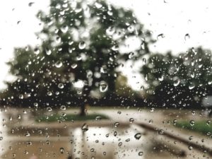
 Many woke up to a wet Sunday morning after overnight thunderstorms rumbled through the area.
At the Salina Municipal Airport, 0.28 of an inch was recorded as of 7 a.m. Sunday. Near the Eagle Radio studios in the southeast Salina, 0.25 of an inch was recorded by 7 a.m. Sunday. More rain fell after 7 a.m.
According to the National Weather Service, scattered storms may redevelop along a warm front over portions of central Kansas this afternoon. A few strong storms with nickel sized hail, wind gusts to 50 mph and locally heavy rain will be possible with the strongest activity. Other storms may drift eastward late tonight bringing some locally heavy rain to portions of central and south central Kansas.
Some storms may linger across the area Monday morning but strong or severe storms are not expected. A few strong and severe storms may accompany a cold front across much of the area on Thursday afternoon and Thursday evening.
Following are rainfall totals as of 7 a.m. Sunday from the Community Collaborative Rain, Hail & Snow Network.
Clay County
12.4 miles north-northeast of Clay Center, 0.12 of an inch
Dickinson County
0.3 of a mile northwest of Enterprise, 0.34 of an inch
0.7 of a mile east of Abilene, 0.38 of an inch
4.6 miles north of Hope, 0.95 of an inch
6 miles north-northeast of Chapman, 0.02 of an inch
0.3 of a mile south of Hope, 0.94 of an inch
5.4 miles east of Abilene, 0.25 of an inch
2.1 miles north-northeast of Carlton, 1.21 inches
7.5 miles north-northwest of Hope, 0.63 of an inch
10.3 miles south of Abilene, 0.72 of an inch
0.7 of a mile west of Abilene, 0.5 of an inch
10.9 miles south of Abilene, 0.78 of an inch
1.1 miles north-northeast of Abilene, 0.49 of an inch
9.4 miles south of Abilene, 0.79 of an inch
Ellsworth County
0.3 of a mile east of Ellsworth, 0.03 of an inch
1.4 miles south of Lorraine, 0.04 of an inch
4.5 miles northeast of Kanopolis, 0.04 of an inch
Lincoln County
4.6 miles south of Beverly, 0.19 of an inch
Marion County
3.2 miles east-southeast of Tampa, 0.2 of an inch
8.5 miles southwest of Hillsboro, 0.17 of an inch
5.3 miles south of Hillsboro, 0.26 of an inch
9.4 miles north of Newton, 0.49 of an inch
12.6 miles north of Newton, 0.43 of an inch
McPherson County
6.6 west-southwest of McPherson, 0.1 of an inch
5.6 miles west of Lindsborg, 0.28 of an inch
0.8 of a mile west-southwest of Inman, 0.12 of an inch
5.3 miles west-southwest of Moundridge, 0.2 of an inch
3 miles west-southwest of Marquette, 0.22 of an inch
3.2 miles north of Canton, 0.07 of an inch
1.4 miles north of Galva, a trace
2.2 miles west of Moundridge, 0.13 of an inch
9.5 miles north of Galva, 0.21 of an inch
4.8 miles west of Moundridge, 0.2 of an inch
2.3 miles north-northeast of Marquette, 0.3 of an inch
6.6 miles east-northeast of McPherson, 0.09 of an inch
1.1 miles west-southwest of Galva, 0.02 of an inch
0.3 of a mile east-northeast of Moundridge, 0.16 of an inch
3.2 miles north-northeast of Marquette, 0.35 of an inch
Mitchell County
4.6 miles south-southwest of Scottsville, 0.03 of an inch
Saline County
0.7 of an mile south-southwest of Salina, 0.4 of an inch
5.9 miles north-northwest of Brookville, 0.39 of an inch
5.7 miles north-northwest of Salina, 0.26 of an inch
8.7 miles north-northeast of Salina, 0.22 of an inch
1.8 miles southeast of Culver, 0.06 of an inch