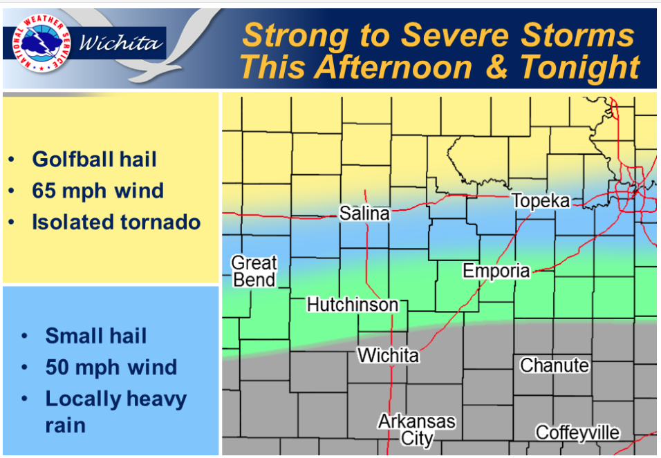
 The severe weather threat from these storms appears low. Once again, thunderstorms are expected to develop along the I-70 corridor late this afternoon and persist into the mid- to late evening across central Kansas. Some of these storms may become severe and will be capable of producing large hail and damaging winds. There is an isolated tornado threat, with the better chances of tornadoes occurring further north along the Kansas-Nebraska border. Storms are expected to develop southward to about the U.S. 50 corridor during the overnight hours, with the severe weather threat waning as the night progresses. Otherwise, another warm day is expected with temperatures climbing into the upper 80s and lower 90s.
Today A 30 percent chance of showers and thunderstorms, mainly after 5pm. Mostly sunny, with a high near 87. Breezy, with a south wind 7 to 12 mph increasing to 15 to 20 mph in the afternoon. Winds could gust as high as 29 mph.
Tonight A 40 percent chance of showers and thunderstorms, mainly after 7pm. Partly cloudy, with a low around 68. South wind 13 to 16 mph, with gusts as high as 24 mph.
Friday A 20 percent chance of showers and thunderstorms. Mostly sunny, with a high near 88. East wind 10 to 15 mph becoming south in the afternoon. Winds could gust as high as 22 mph.
Friday Night A 30 percent chance of showers and thunderstorms. Partly cloudy, with a low around 68. Southeast wind 8 to 13 mph.
Saturday Mostly sunny, with a high near 90. South wind 9 to 18 mph, with gusts as high as 28 mph.