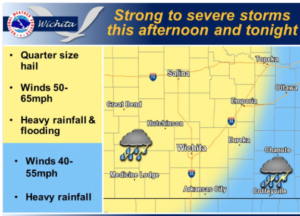
 As a strong cold front pushes through the region today strong to severe thunderstorms will be possible. Isolated storms are possible during the early to middle afternoon hours; however, confidence is much high towards the evening hours when storms become more widespread. The primary threats will be quarter size hail, winds up to 55 to 65 mph, and heavy rain which may lead to localized flooding concerns.
Expect the cold front and thunderstorm activity to linger across south central and southeast Kansas during the overnight hours before exiting the state during the morning hours on Saturday. Saturday lingering clouds and a cooler, drier post frontal air mass will bring below normal temperatures to the area.
Today: Showers and thunderstorms likely, mainly after 5 p.m. Mostly sunny, with a high near 90. South wind 7 to 15 mph, with gusts as high as 21 mph. Chance of precipitation is 60%.
Friday Night: Showers and thunderstorms, mainly before 1 a.m. Low around 62. South southeast wind 8 to 14 mph becoming north northwest after midnight. Winds could gust as high as 18 mph. Chance of precipitation is 80%.
Saturday: Mostly cloudy, then gradually becoming sunny, with a high near 78. North northwest wind 14 to 17 mph, with gusts as high as 26 mph.
Saturday Night: Mostly clear, with a low around 55. North wind 5 to 10 mph becoming light and variable.