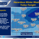
 An arctic airmass will move southward into the region today into tonight, with sharply falling temperatures and potentially dangerous wind chills developing. A light glaze of ice from light freezing drizzle will be possible this morning in south-central and southeast Kansas. This could result in very slick roads and overpasses. Accumulating snow and blowing snow will then spread eastward across the region from midday into early this evening, with sharply reduced visibilities and poor driving conditions. Low temperatures tonight are forecast from near zero to 8 below, with wind chills of 15 to 24 below zero into Sunday morning.
Saturday: Snow, mainly before 4pm. Areas of blowing snow after 9am. High near 18. Wind chill values as low as -14. Blustery, with a north wind around 25 mph, with gusts as high as 34 mph. Chance of precipitation is 90%. New snow accumulation of 2 to 4 inches possible.
Saturday Night: Areas of blowing snow before 11pm. Mostly cloudy during the early evening, then gradual clearing, with a low around -6. Wind chill values as low as -18. Blustery, with a north northwest wind 18 to 23 mph decreasing to 6 to 11 mph after midnight. Winds could gust as high as 32 mph.
Sunday: Sunny, with a high near 17. Wind chill values as low as -19. Light and variable wind becoming south southwest 5 to 8 mph in the afternoon.
Sunday Night: Clear, with a low around 4. South southwest wind around 8 mph.
Monday: Sunny, with a high near 32.
Monday Night: Clear, with a low around 16.
Tuesday: Sunny, with a high near 41.
Tuesday Night: Mostly clear, with a low around 22.
Wednesday: Mostly sunny, with a high near 47.
Wednesday Night: Mostly clear, with a low around 25.
Thursday: Sunny, with a high near 45.
Thursday Night: Mostly clear, with a low around 26.
Friday: Mostly sunny, with a high near 47.