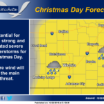
Christmas day there will be a good chance for some strong to isolated severe thunderstorms during the afternoon and early evening hours. Severe wind will be the primary threat with some storms having the potential to produce winds in excess of 60 mph.
Today: Increasing clouds, with a high near 43. Calm wind becoming south around 6 mph in the afternoon.
Tonight: A slight chance of drizzle, snow, and freezing drizzle before 3am, then a slight chance of freezing drizzle between 3am and 5am, then a slight chance of freezing drizzle and sleet after 5am. Mostly cloudy, with a low around 32. South wind 6 to 13 mph, with gusts as high as 22 mph. Chance of precipitation is 20%.
Friday: Partly sunny, with a high near 47. South southwest wind 8 to 16 mph, with gusts as high as 28 mph.
Friday Night: Partly cloudy, with a low around 23. West southwest wind 5 to 7 mph becoming light and variable after midnight.
Saturday: Mostly sunny, with a high near 46. Light and variable wind becoming southeast 5 to 10 mph in the morning.
Saturday Night: A 30 percent chance of showers after midnight. Patchy fog between 7pm and midnight. Otherwise, mostly cloudy, with a low around 41.
Christmas Day: Showers likely and possibly a thunderstorm before noon, then a chance of showers and thunderstorms after noon. Mostly cloudy, with a high near 59. Breezy. Chance of precipitation is 70%.
Sunday Night: A 20 percent chance of showers before midnight. Partly cloudy, with a low around 27. Breezy.
Monday: Sunny, with a high near 40.
Monday Night: Mostly clear, with a low around 20.
Tuesday: Mostly sunny, with a high near 41.
Tuesday Night: Partly cloudy, with a low around 26.
Wednesday: Partly sunny, with a high near 46.