.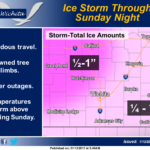 An ice storm will impact the region today through Sunday night. Areas of freezing rain, freezing drizzle and possibly sleet will impact mainly southeast Kansas through Saturday morning, with the freezing precipitation gradually expanding north to include the entire area by Saturday night. The heaviest freezing rain will likely occur Saturday night and Sunday, with substantial ice accumulations expected. Temperatures will gradually warm above freezing from the south late Saturday night and Sunday, changing the precipitation to all rain with the exception of locations generally northwest of Great Bend to Salina. Expect areas of downed tree limbs and power outages, along with hazardous travel. Some uncertainty remains regarding temperatures. A change of 1 or 2 degrees in either direction will have large implications on forecast accuracy.