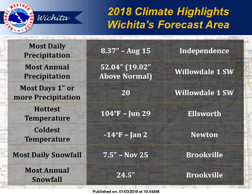
 Both Brookville and Ellsworth made the 2018 climate highlights from the National Weather Service office in Wichita (NWSW).
The 2018 climate highlights from NWSW’s forecast area included the following.
- Hottest Temperature: 104 degrees on June 29 in Ellsworth
- Most Daily Snowfall: 7.5 inches on November 25 in Brookville
- Most Annual Snowfall: 24.5 inches in Brookville
While our temperatures are anticipated to warm up a bit over the next week and there’s a slight chance for snow late this weekend, it doesn’t look as though we will come close to any of the above highlights any time soon.
Here’s the forecast from NWSW:
Friday
Sunny, with a high near 54. Southwest wind 5 to 8 mph becoming west northwest in the morning.
Friday Night
Clear, with a low around 28. West southwest wind around 6 mph.
Saturday
Sunny, with a high near 58. Light and variable wind becoming south southeast 5 to 7 mph in the morning.
Saturday Night
Partly cloudy, with a low around 32. South wind around 8 mph.
Sunday
Mostly cloudy, with a high near 51.
Sunday Night
A chance of rain after midnight, mixing with snow after 5 a.m. Mostly cloudy, with a low around 36. Chance of precipitation is 40 percent.
Monday
A slight chance of rain and snow before 7 a.m., then a slight chance of rain between 7 a.m. and noon. Mostly sunny, with a high near 54. Chance of precipitation is 20 percent.
Monday Night
Mostly clear, with a low around 32.
Tuesday
Sunny, with a high near 55.
Tuesday Night
Mostly clear, with a low around 29.
Wednesday
Sunny, with a high near 53.
Wednesday Night
Mostly clear, with a low around 34.
Thursday
Mostly sunny, with a high near 52.