 From storms with hail and wind to flood warnings, it looks to be another weather weekend for our area.
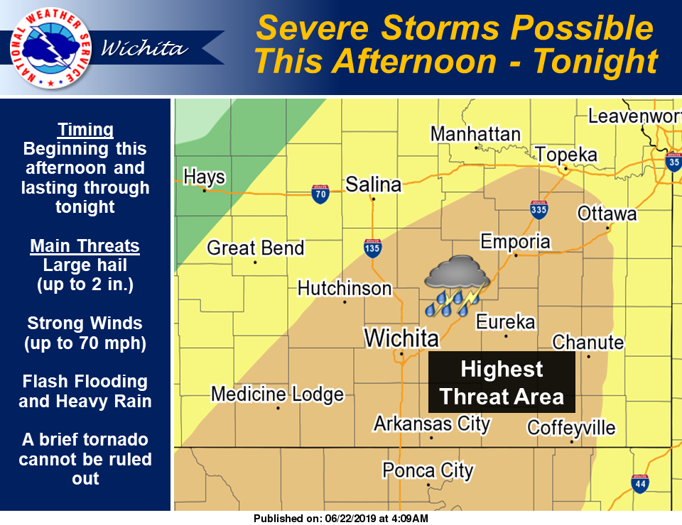
According to the National Weather Service (NWS), scattered to numerous thunderstorms are expected this afternoon and evening, especially across southern Kansas. Storms are likely to be severe. The main threats in strongest storms will be hail up to approximately two inches in diameter and damaging winds to 70 mph, though a brief tornado cannot be ruled out during the afternoon hours.
In addition to the severe weather threat, NWS has indicated that flash flooding will be possible as thunderstorms that develop are likely to produce very heavy rainfall rates. Rises along area rivers are also possible.
Strong to severe storms are expected again Sunday afternoon and evening, especially in southeast Kansas. Similar to Saturday, the main threats will be hail up to around 2 inches in diameter, wind
gusts to 70 mph, and flash flooding. A brief tornado cannot be ruled out.
Flood warnings
NWS has issued flood warnings for Marion and McPherson counties until 12:15 p.m. Saturday.
“At 7:35 a.m. CDT, doppler radar showed that the rain had moved out of the warned area. However, local law enforcement reported that flooding continued in the Peabody area of Marion county. Rainfall overnight ranged from two to over five inches across parts of Marion, McPherson and Harvey counties. Excessive runoff will likely continue to keep water levels high across the warned area through at least early afternoon. Some locations that will experience flooding include Hesston, Hillsboro, Marion, Peabody, Florence, Goessel, Walton, Burns, Newton Airport, and Marion Lake. This includes Interstate 135 between mile markers 34 and 46,” NWS noted.
According to NWS, minor flooding also is expected on the Smoky Hill River at Lindsborg. NWS is forecasting that the river will rise above flood stage (21.0 feet) by late this morning and continue to rise to near 21.6 feet by this evening. The river will fall below flood stage by early Sunday morning. At 21.0 feet, the south bank overflows extend out to 20 feet from bank and Old Mill Park floods along with low lying fields in rural areas, NWS noted.
Overnight rainfall
A storm that rolled through the area early Saturday morning brought with it varying amounts of rainfall. In Saline County, rainfall ranged from 0.29 of an inch just north of Salina to 1.05 inches near Brookville. In southeast Salina, near the Eagle Communication studios, 0.50 of an inch was recorded. Other rainfall ranges for counties in our area for the 24-hour reporting period ending at 7 a.m. Saturday include the following.
Clay County: 0.67 of an inch in the northwest part of the county to 1.05 inches in the northeast part of the county
Cloud County: 0.25 of an inch in the northwest part of the county was the only amount reported
Dickinson County: 0.16 of an inch in the south-central part of the county to 1.45 inches in the northwest part of the county.
Ellsworth County: 0.25 of an inch in the western part of the county to 1.33 inches in the eastern part of the county
Lincoln County: 0.26 of an inch in the southeastern part of the county to 0.78 of an inch in the east-central part of the county
Marion County: 1.03 inches in the east-central part of the county to 3.39 inches in the southwestern part of the county
McPherson County: 0.76 of an inch in the south-central part of the county to 2.0 inches in the northeast part of the county
Mitchell County: 0.18 of an inch in the central part of the county to 0.81 of an inch in the southwestern part of the county
Ottawa County: 0.91 of an inch in the northwest part of the county was the only amount reported
Republic County: 0.51 of an inch in the central part of the county to 1.81 inches in the northwest part of the county