There was a variety of rainfall totals for the 24-hour period that ended at 7 a.m. Sunday and more rain is expected later this week.
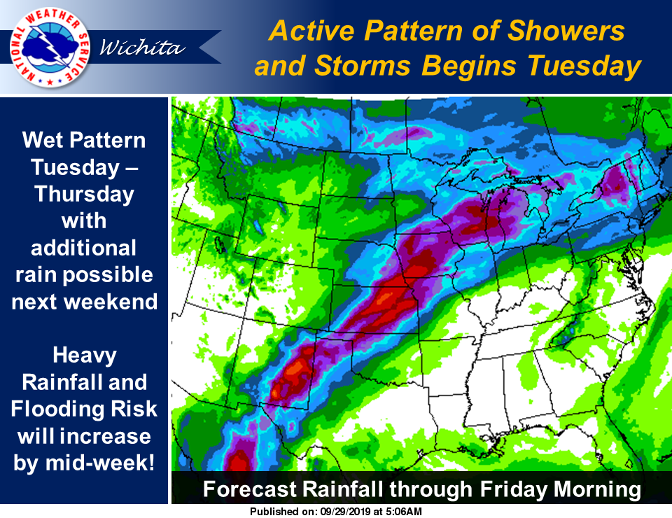
According to the National Weather Service (NWS), multiple rounds of showers and thunderstorms are likely from late Monday or early Tuesday through at least Thursday this week, with an increased risk of very heavy rain throughout this period. As a result, area, river, and flash flooding will all be possible, NWS noted. Although a few strong storms cannot be ruled out, NWS has indicated that widespread severe weather looks unlikely at this time.
Following are rainfall totals as of 7 a.m. Sunday from the Community Collaborative Rain, Hail & Snow Network.
Clay County
- 6.7 miles west-northwest of Clay Center, 0.64 of an inch
- 3.2 miles southwest of Morganville, 0.74 of an inch
Cloud County
- 9.3 miles south-southwest of Concordia, 0.15 of an inch
Dickinson County
- 1 mile north-northwest of Chapman, 0.49 of an inch
- 6 miles north-northeast of Chapman, 0.51 of an inch
- 0.3 of a mile south of Hope, 0.12 of an inch
- 5.9 miles north-northwest of Abilene, 0.3 of an inch
- 7.5 miles north-northwest of Hope, 0.25 of an inch
- 10.3 miles south of Abilene, 0.22 of an inch
- 0.7 of a mile west of Abilene, 0.2 of an inch
- 10.9 miles south of Abilene, 0.15 of an inch
- 1.1 miles north-northeast of Abilene, 0.21 of an inch
Ellsworth County
- 4.1 miles north of Geneseo, 0.12 of an inch
- 0.8 of a mile southwest of Kanopolis, 0.15 of an inch
- 0.3 of a mile east of Ellsworth, 0.2 of an inch
- 2.5 miles east-southeast of Lorraine, 0.2 of an inch
- 4.5 miles northeast of Kanopolis, 0.2 of an inch
Jewell County
- 2.6 miles east-northeast of Webber, 0.53 of an inch
- 0.3 of an mile west of Formoso, 0.85 of an inch
Marion County
- 3.2 miles east-southeast of Tampa, 0.25 of an inch
- 5.3 miles south of Hillsboro, 0.11 of an inch
- 9.4 miles north of Newton, 0.11 of an inch
- 12.6 miles north of Newton, 0.11 of an inch
McPherson County
- 6.6 miles west-southwest of McPherson, 0.09 of an inch
- 5.6 miles west of Lindsborg, 0.11 of an inch
- 0.8 of a mile west-southwest of Inman, 0.09 of an inch
- 5.3 miles west-southwest of Moundridge, 0.06 of an inch
- 3 miles west-southwest of Marquette, 0.10 of an inch
- 3.2 miles north of Canton, 0.19 of an inch
- 1 mile north of Moundridge, 0.24 of an inch
- 1.4 miles north of Galva, 0.06 of an inch
- 2.2 miles west of Moundridge, 0.23 of an inch
- 9.5 miles north of Galva, 0.14 of an inch
- 4.8 miles west of Moundridge, 0.07 of an inch
- 0.3 of a mile east of Canton, 0.22 of an inch
- 2.3 miles north-northeast of Marquette, 0.12 of an inch
- 6.6 miles east-northeast of McPherson, 0.13 of an inch
- 1.1 miles west-southwest of Galva, 0.1 of an inch
Mitchell County
- 4.6 miles south-southwest of Scottsville, 0.42 of an inch
- 9.9 miles south-southwest of Beloit, 0.31 of an inch
- 6.9 miles northeast of Beloit, 0.41 of an inch
Ottawa County
- 7 miles north-northwest of Ada, 0.15 of an inch
Republic County
- 4.2 miles north of Belleville, 0.46 of an inch
- 1.2 miles southeast of Munden, 0.42 of an inch
- 0.5 of a mile south of Belleville, 0.42 of an inch
- 6.1 miles north of Courtland, 0.75 of an inch
- 1 mile north-northwest of Republic, 0.83 of an inch
- 1.1 miles north of Scandia, 0.82 of an inch
Saline County
- 8 miles north-northeast of Brookville, 0.17 of an inch
- 0.7 of a mile south-southwest of Salina, 0.17 of an inch
- 0.8 of a mile south of Salina, 0.16 of an inch
- 5.9 miles north-northwest of Brookville, 0.38 of an inch
- 5.7 miles north-northwest of Salina, 0.09 of an inch
- 2.9 miles northeast of Salina, 0.28 of an inch
- 1.8 miles southeast of Culver, 0.13 of an inch