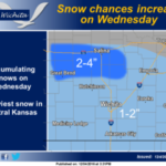
 Confidence is increasing on a chance for accumulating snowfall on Wednesday. Snowfall chances will increase initially across Central Kansas early Wednesday morning, with chances increasing gradually to the south-southeast along Highway 50 and Highway 54 by Wednesday afternoon. Current projections suggest the heaviest snowfall will occur along the Interstate 70 corridor with 2 to 4 inches possible. Snowfall amounts of 1 to 2 inches look possible across South Central and Southeast Kansas. The forecast is still 24-36 hours out, so location of the heaviest snow could still change as Wednesday approaches.
Today: Mostly sunny, with a high near 56. South wind 10 to 18 mph, with gusts as high as 26 mph.
Tonight: Partly cloudy, with a low around 25. South wind 8 to 14 mph becoming north after midnight. Winds could gust as high as 22 mph.
Tuesday: Sunny, with a high near 40. North northwest wind 7 to 10 mph.
Tuesday Night: A 30 percent chance of snow after midnight. Increasing clouds, with a low around 20. Northeast wind 5 to 9 mph.
Wednesday: Snow likely, mainly before noon. Cloudy, with a high near 27. Northeast wind 10 to 13 mph becoming north northwest in the afternoon. Winds could gust as high as 18 mph. Chance of precipitation is 60%.
Wednesday Night: Mostly clear, with a low around 9.
Thursday: Sunny, with a high near 22.
Thursday Night: Mostly clear, with a low around 6.
Friday: Mostly sunny, with a high near 29.
Friday Night: Partly cloudy, with a low around 21.
Saturday: Mostly sunny, with a high near 41.
Saturday Night: Partly cloudy, with a low around 25.
Sunday: Mostly sunny, with a high near 42.