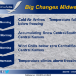
 Big changes are coming by midweek. The cold air arrives Tuesday morning with temperatures falling below freezing. On Wednesday morning, accumulating snow is expected to develop across parts of Central and South Central Kansas. By Thursday morning, wind chills will fall below zero over Central and parts of South Central Kansas. Friday afternoon the temperature will climb above freezing.
Today: Patchy fog between 10am and 11am. Otherwise, cloudy through mid morning, then gradual clearing, with a high near 50. Calm wind becoming west 5 to 8 mph in the morning.
Tonight: Clear, with a low around 30. West southwest wind 5 to 7 mph becoming south after midnight.
Monday: Mostly sunny, with a high near 54. South wind 8 to 16 mph, with gusts as high as 26 mph.
Monday Night: Partly cloudy, with a low around 25. Blustery, with a north northeast wind 6 to 11 mph becoming north 16 to 21 mph after midnight. Winds could gust as high as 29 mph.
Tuesday: Mostly sunny, with a high near 38. North wind 9 to 18 mph, with gusts as high as 28 mph.
Tuesday Night: A 30 percent chance of snow after 1am. Mostly cloudy, with a low around 19.
Wednesday: A 50 percent chance of snow. Patchy blowing snow between 10am and 5pm. Mostly cloudy, with a high near 25.
Wednesday Night: A 30 percent chance of snow before 7pm. Mostly clear, with a low around 9.
Thursday: Sunny, with a high near 26.
Thursday Night: Mostly clear, with a low around 8.
Friday: Sunny, with a high near 33.
Friday Night: Partly cloudy, with a low around 22.
Saturday: Partly sunny, with a high near 40.