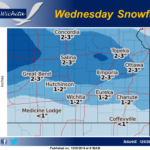
 An approaching storm system will bring increasing chances for snow to Central KS during the early morning hours on Wed. Snow will spread eastward across the area during the day before diminishing on Wed evening. Gusty northeast winds may result in blowing and drifting snow across mainly Central Kansas. The highest accumulations are expected to remain along the I-70 corridor where 2-4 inches will be possible. A sharp gradient will exist as you move south with only trace amounts possible along the Oklahoma state line.
Today: Mostly sunny, with a high near 56. South wind 11 to 18 mph, with gusts as high as 28 mph.
Tonight: Partly cloudy, with a low around 25. South wind 8 to 16 mph becoming north after midnight. Winds could gust as high as 23 mph.
Tuesday: Sunny, with a high near 40. North northwest wind 7 to 11 mph.
Tuesday Night: A 30 percent chance of snow after midnight. Increasing clouds, with a low around 21. North northeast wind 5 to 10 mph.
Wednesday: Snow likely, mainly before noon. Cloudy, with a high near 27. North wind 11 to 14 mph, with gusts as high as 20 mph. Chance of precipitation is 60%.
Wednesday Night: Mostly clear, with a low around 9.
Thursday: Sunny, with a high near 22.
Thursday Night: Mostly clear, with a low around 7.
Friday: Mostly sunny, with a high near 29.
Friday Night: Partly cloudy, with a low around 21.
Saturday: Mostly sunny, with a high near 41.
Saturday Night: Partly cloudy, with a low around 25.
Sunday: Mostly sunny, with a high near 42.