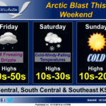
 Patchy light drizzle and freezing drizzle is possible late Thursday night and Friday morning, with a very light glaze of ice accumulation possible. Otherwise, an Arctic cold front will blast south across the region, supporting much colder temperatures and dangerous wind chills this weekend. Daytime highs on Saturday will be in the morning, with falling temperatures through the day. Stout north winds will support wind chill readings dropping well below zero Saturday through early Sunday. Additionally, areas of light snow and flurries are expected Saturday, with light accumulations possible.