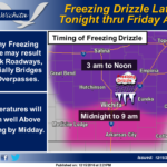
 Patchy freezing drizzle is expected late Thursday night through Friday morning across much of central and part of eastern Kansas. The freezing drizzle could result in a light coating of ice on exposed surfaces, especially bridges and overpasses. So be prepared for possible slick roadways Friday morning.
Friday: Areas of freezing drizzle before 10am, then areas of drizzle. Cloudy, with a high near 41. South southeast wind 9 to 13 mph becoming north northeast in the afternoon. Winds could gust as high as 21 mph.
Friday Night: Cloudy, with a low around 16. Blustery, with a north northwest wind 10 to 15 mph increasing to 18 to 23 mph after midnight. Winds could gust as high as 31 mph.
Saturday: Snow likely, possibly mixed with freezing drizzle, becoming all snow after 7am. Areas of blowing snow. Cloudy, with a high near 16. Wind chill values as low as -15. Blustery, with a north wind around 25 mph, with gusts as high as 34 mph. Chance of precipitation is 60%.
Saturday Night: Mostly clear, with a low around -5. Blustery, with a north northwest wind 18 to 23 mph decreasing to 6 to 11 mph after midnight. Winds could gust as high as 31 mph.
Sunday: Sunny, with a high near 19.
Sunday Night: Clear, with a low around 5.
Monday: Sunny, with a high near 32.
Monday Night: Mostly clear, with a low around 15.
Tuesday: Sunny, with a high near 42.
Tuesday Night: Mostly clear, with a low around 20.
Wednesday: Mostly sunny, with a high near 43.
Wednesday Night: Partly cloudy, with a low around 24.
Thursday: Mostly sunny, with a high near 42.