.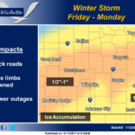 Multiple rounds of freezing rain will affect the area between Friday and early Monday. The freezing rain may result in hazardous travel conditions as well as tree damage and power outages. The greatest accumulations of ice are expected late Friday night into Saturday and then Saturday night into early Sunday. The graphic shows total ice accumulation. For some areas roughly east of I-35 and south of Highway 54, temperature may warm enough Saturday afternoon to cause substantial melting. This would divide the total shown between two separate events for that area. Temperatures will rise well above freezing for most of the area during the day on Sunday. Precipitation will end with sleet or snow mix across portions of Central Kansas on Monday