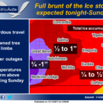
 The full brunt of the ice storm is expected across the region this afternoon through Sunday. The intensity of the freezing rain will increase tonight, with periods of freezing rain leading to hazardous travel, downed power lines and power outages. Ice accumulations are expected to be the heaviest for areas northwest of the Kansas Turnpike. Storm total ice accumulations by late Sunday will range from a quarter to a half an inch in southeast Kansas to a half to 1 inch across portions of Central Kansas. By Sunday afternoon the freezing rain will slowly change over to rain as warmer air increases from southeast Kansas to Central Kansas. The freezing rain will linger the longest over Central Kansas from Great Bend to Lincoln.
Today: A chance of freezing rain after noon. Cloudy, with a high near 32. North wind around 6 mph. Chance of precipitation is 30%.
Tonight: Freezing rain likely, possibly mixed with sleet before 7pm, then freezing rain. Low around 25. Northeast wind 3 to 5 mph. Chance of precipitation is 80%. New ice accumulation of 0.1 to 0.3 of an inch possible. Little or no sleet accumulation expected.
Sunday: Freezing rain before 2pm, then rain or freezing rain likely. High near 33. East northeast wind 5 to 7 mph. Chance of precipitation is 80%. New ice accumulation of 0.1 to 0.3 of an inch possible.
Sunday Night: Rain or freezing rain, becoming all rain after 1am. Low around 32. East northeast wind 6 to 9 mph. Chance of precipitation is 90%.
M.L.King Day: Rain likely, mainly before noon. Cloudy, with a high near 45. East northeast wind 7 to 11 mph becoming northwest in the afternoon. Chance of precipitation is 60%.
Monday Night: A 20 percent chance of rain before midnight. Mostly cloudy, with a low around 26.
Tuesday: Mostly sunny, with a high near 42.
Tuesday Night: Mostly clear, with a low around 26.
Wednesday: Sunny, with a high near 53.
Wednesday Night: Mostly clear, with a low around 32.
Thursday: Mostly sunny, with a high near 57.
Thursday Night: Partly cloudy, with a low around 37.
Friday: Partly sunny, with a high near 55.