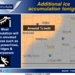
 Additional freezing rain accumulation is expected tonight over mainly central and portions of northeast Kansas. An additional quarter inch of ice accumulation can be expected tonight with most of this occurring on elevated surfaces such as trees, power lines, bridges and overpasses.
Tonight: Freezing rain before 9pm, then rain or freezing rain between 9pm and 3am, then rain after 3am. Low around 32. North northeast wind 5 to 10 mph. Chance of precipitation is 100%. Total nighttime ice accumulation of 0.1 to 0.3 of an inch possible.
M.L.King Day: Rain, mainly before 3pm. High near 35. North northeast wind around 10 mph becoming northwest in the afternoon. Chance of precipitation is 80%.
Monday Night: A slight chance of rain, mixing with freezing rain after 8pm, then gradually ending. Cloudy, with a low around 27. Northwest wind around 10 mph. Chance of precipitation is 20%.
Tuesday: Mostly cloudy, then gradually becoming sunny, with a high near 43. Northwest wind 6 to 8 mph becoming west southwest in the afternoon.
Tuesday Night: Mostly clear, with a low around 26. Southwest wind 5 to 7 mph.
Wednesday: Sunny, with a high near 52.
Wednesday Night: Mostly clear, with a low around 33.
Thursday: Mostly sunny, with a high near 55.
Thursday Night: Mostly cloudy, with a low around 37.
Friday: A 20 percent chance of rain before noon. Partly sunny, with a high near 54.
Friday Night: Mostly cloudy, with a low around 35.
Saturday: Mostly sunny, with a high near 53.
Saturday Night: Mostly cloudy, with a low around 32.
Sunday: Partly sunny, with a high near 48.