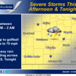
 Severe thunderstorms are possible late this afternoon and evening, as a cold front approaches from the northwest. Large hail and damaging winds will be the main hazards, with heavy rain and minor flooding possible tonight across southern Kansas as storms consolidate into a large complex.
This hazardous weather outlook is for portions of Central Kansas, South Central Kansas and Southeast Kansas.
.DAY ONE…Today and Tonight
A few showers and thunderstorms are possible early this morning. The strongest activity will be capable of brief heavy rain and cloud to ground lightning.
Severe storms are possible across central and south central Kansas this afternoon and evening along an approaching cold front. Hail up to the size of golfballs and wind gusts to 70 mph are the main hazards. Heavy rain and localized flooding may result tonight across
southern Kansas.
.DAYS TWO THROUGH SEVEN…Sunday through Friday
Off-and-on shower and thunderstorm chances will continue areawide Sunday and Sunday night, with the greatest potential for a few severe storms and heavy rain over far southern Kansas.
Periodic thunderstorm chances will continue to impact the region through much of next week. Some of the storms may be strong or severe, with locally heavy rain and flooding.
.SPOTTER INFORMATION STATEMENT…
Spotter activation may be needed this afternoon and early evening across central and south-central Kansas.