 Our holiday weekend could include a bit of rain.
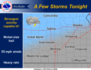
According to the National Weather Service Office in Wichita NWS-W), thunderstorm chances are expected to increase overnight across portions of central and north-central Kansas. A few strong storms are possible, capable of nickel size hail, 55 mph winds, and locally heavy rain.
A prolonged period of unsettled weather is expected Saturday night through mid to late next week, with periodic chances for showers and thunderstorms across the region. While a handful of strong to marginally severe thunderstorms is possible during this period, the main threat will likely be locally heavy rain and associated flooding concerns.
Tonight
A 30-percent chance of showers and thunderstorms, mainly after 1 a.m. Increasing clouds, with a low around 75. Breezy, with a south wind 10 to 20 mph, with gusts as high as 28 mph.
Saturday
A slight chance of showers and thunderstorms before 7 a.m., then a chance of showers and thunderstorms after 1 p.m. Mostly sunny, with a high near 94. South wind 11 to 14 mph, with gusts as high as 20 mph. Chance of precipitation is 30 percent.
Saturday night
A 40-percent chance of showers and thunderstorms. Mostly cloudy, with a low around 71. South southeast wind 7 to 11 mph.
Sunday
A 50-percent chance of showers and thunderstorms. Partly sunny, with a high near 87. South wind 7 to 11 mph.
Sunday night
Showers and thunderstorms likely, mainly after 1 a.m. Mostly cloudy, with a low around 70. Chance of precipitation is 60 percent.
Labor Day
A 40-percent chance of showers and thunderstorms, mainly before 1 p.m. Mostly cloudy, with a high near 85.
Monday night
Showers and thunderstorms likely, mainly after 1 a.m. Mostly cloudy, with a low around 70. Chance of precipitation is 60 percent.